Geology

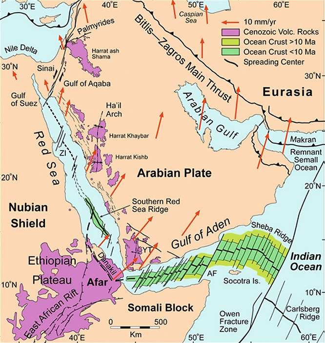
Tectonic map of the Red Sea region, highlighting the Afar Triple Junction and key geological features such as the Arabian Plate, Nubian Shield, and Somali Block, showcasing rift systems that underscore the region’s significant hydrocarbon potential and strategic importance for exploration (after Bosworth, 2015). Red arrows are GPS velocities in a Eurasia-fixed reference frame from ArRajehi et al., 2010.
Nafka Energy – Pursuing a New Paradigm in African Oil and Gas Exploration in Eritrea
Offshore Eritrea is an underexplored, highly accessible, frontier geologic setting that likely hosts billions of barrels of yet untapped hydrocarbons. It remains one of the last truly frontier oil and gas basins in the world, with only 12 deep and 11 shallow water exploration wells drilled offshore along its 1,215 km continental shoreline. Excluding the axial trough, the Eritrean offshore covers an era of approximately 75,000 km2. This is an average of one exploratory well per 3,260 km2. None of these wells penetrated the most promising reservoir objectives which lie beneath the Miocene massive salt section. Offshore Eritrea could become one of the most significant hydrocarbon plays in East Africa.

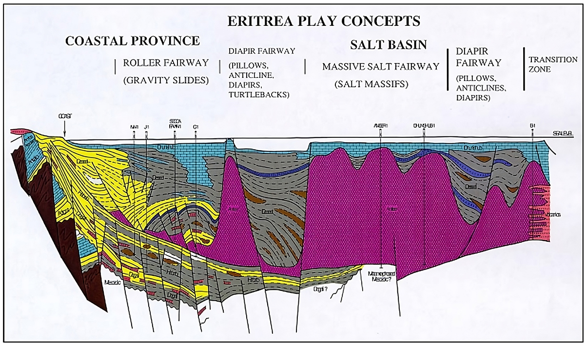
Schematic cross-section showing play types of the Eritrean Red Sea margin (after Savoyat et al., 1989). Based on well control and extensive 2D reflection seismic profiles. The greatest exploration potential lies in untested, subsalt structural and stratigraphic traps.

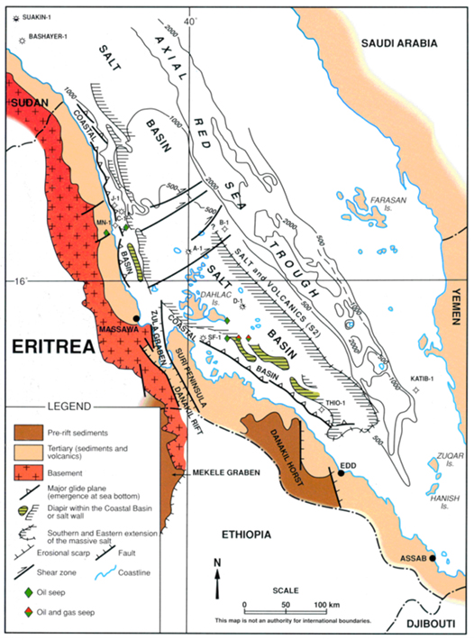
Present day structural map of the Eritrean Red Sea (after Savoyat et al, 1989). The most prospective areas for hydrocarbon exploration lie within the Salt Basins that parallel the coastline and are far removed from the Red Sea Axial Trough.
Why Eritrea’s Offshore Basin Represents High-Value Opportunity
Structural and Stratigraphic Parallels
Underexplored with High-Quality Source Rocks
Proven Reservoir Models

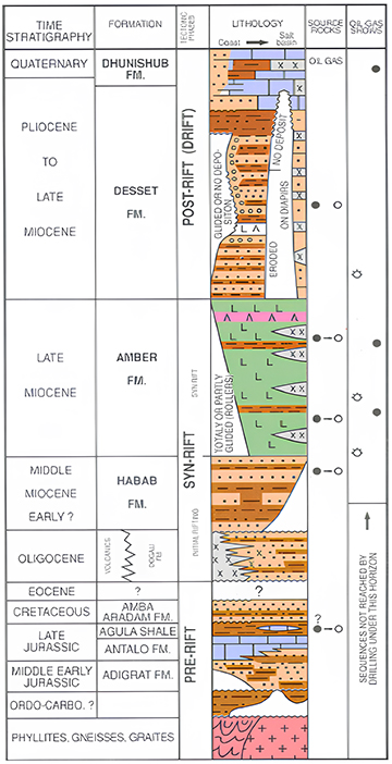
Tectonostratigraphic chart of the Eritrean Red Sea (after Savoyat et al., 1989). Massive halite beds of the Late Miocene Amber Formation provide excellent top seal for reservoir rocks in the underlying Habab and older formations. Salt walls and diapirs in the Amber Formation also provide conduits for heat to escape and thereby moderated long-term heat flow.
Regional Geology
Geological Context
The Eritrean offshore area is part of the Red Sea Rift System, formed by the divergence of the African and Arabian plates starting in the Oligocene and continuing to the Present-day. This tectonic activity has led to the preservation and development of sedimentary basins with sequences from the Mesozoic and Cenozoic eras, including evaporites, carbonates, and siliciclastic deposits. These formations constitute potential hydrocarbon systems.
The Red Sea’s formation was linked to the separation of Arabia from Africa, and later to the formation of the Afar triple junction. Rifting in the southern Red Sea, including offshore Eritrea, began in the Late Oligocene epoch (approximately 27.5 to 23.0 million years ago). This rifting was initially accompanied by volcanic activity, including basaltic dikes and layered gabbro intrusions. From its onset, the Eritrean Red Sea was connected to the World Ocean, which resulted in the deposition of marine strata including organic rich rocks.
Sedimentary Basins and Hydrocarbon Potential
The offshore sedimentary basins of Eritrea contain sequences of Mesozoic and Cenozoic sediments, including marine deposits and evaporites. These basins have been the focus of hydrocarbon exploration, with several wells drilled between 1966 and 1977. Although this early exploration encountered potential hydrocarbon shows, commercial production was not established.
Key Takeaways
- Eritrea's offshore Red Sea region is characterized by a dynamic geological history that superimposed Cenozoic Red Sea rifting on older Mesozoic basins and the Nubia-Arabia crystalline basement.
- With a proven geological framework, structural analogs to Sudan, Saudi Arabia, and Egypt, and validated hydrocarbon indicators, Eritrea’s offshore basins present a strategic opportunity for high-return exploration.
- The Gulf of Suez, Midyan Basin, and Sudanese Red Sea margin establish a clear exploration model for the Eritrean offshore.
- Eritrea offers a combination of proven petroleum system architecture and frontier upside — making it a rare high-reward, low-exploration cost opportunity in East Africa.
Additional Highlights
Proven Rift Basin Maturation
Eritrea’s offshore basins have the same stratigraphic sequence and have undergone the same hydrocarbon maturation processes seen in commercially successful oil and gas fields in the region, minimizing exploration risk.
Eritrea’s offshore blocks closely resemble the structure, stratigraphy, and burial histories of the Gulf of Suez’s successful petroleum systems, justifying investor confidence in Nakfa Energy’s prospects.